High Flows Continue Across East-Central and Northeastern Saskatchewan
Warmer temperatures forecasted across east-central and northeastern Saskatchewan are expected to accelerate the melting of remaining snowpack and prolong high water levels in several regions already dealing with flooding and dangerous runoff conditions.

According to the Saskatchewan Water Security Agency (WSA), while some areas have started to see water levels recede, other river basins have not yet reached their peak. Officials warn that additional runoff from melting snow could cause flows to rise again in some areas over the coming days.
The ongoing flooding is being driven by a combination of a late spring thaw, above-average snowpack, and additional snowfall from late-season spring storms.
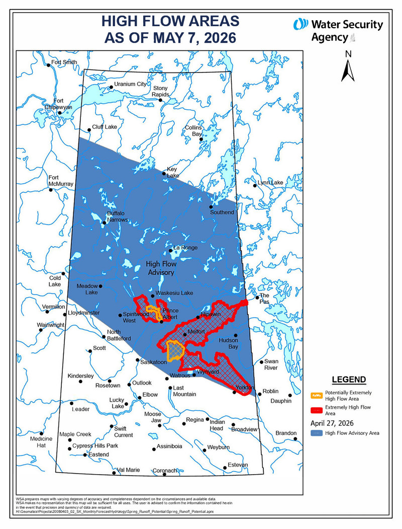
High Flow Advisory Remains in Effect
The WSA's High Flow Advisory, originally issued in April and updated on May 4, remains in effect for portions of the province, including the Quill Lakes region, the Carrot River basin, and parts of the Assiniboine River basin.
Areas north of the Assiniboine Basin in east-central Saskatchewan that still have remaining snowpack could experience another surge in flows. The WSA says some locations may see water levels similar to - or slightly higher than - peaks already observed earlier this spring, particularly along the Assiniboine River near Kamsack.
Above-normal flows are expected to continue for several more days.
River Conditions Across the Region
The Carrot River has already peaked in the upper portions of the basin, and some downstream areas are beginning to slowly recede. However, several sections of the river system remain extremely high.
In the Red Deer River Basin south of Hudson Bay, most rivers and tributaries continue to rise and are expected to peak within the next few days.
Near Prince Albert, active snowmelt is causing significant increases in river levels. The WSA says the Sturgeon River near Prince Albert is currently experiencing extremely high flows, with nearby systems such as the Spruce River and Garden River also expected to rise substantially.
Record and Near-Record Water Flows Reported
The WSA says some rivers are seeing record-breaking water flows.
On the Carrot River system, Smokey Burn recorded nearly 1,000 cubic metres per second (m3/s), compared to a typical seasonal flow of around 200 m3/s. Officials say this is the highest flow ever recorded at that location.
At Armley, flows approached 400 m3/s - the second-highest reading on record - while normal flows for this time of year are usually around 70 m3/s.
In the Quill Lakes basin, preliminary assessments indicate that flows on Ironspring Creek, Magnusson Creek, and Quill Creek may also be the highest ever recorded.
Emergency Response and Support Continues
The WSA says it continues to work directly with affected communities, providing updated flow information and support as conditions change. Officials have proactively contacted communities located in areas facing extremely high flows and have made more than 1,200 calls and emails related to the flooding situation.
Communities across the affected regions have been working around the clock to protect roads, infrastructure, and properties from flood damage.
The Saskatchewan Public Safety Agency (SPSA) remains in communication with communities at risk and continues coordinating resources and emergency assistance where needed.
Residents and property owners affected by flooding may be eligible for assistance through Saskatchewan's Emergency Flood Damage Reduction Program (EFDRP), which helps fund emergency flood protection measures for communities, rural municipalities, businesses, rural residences, cottages, and drinking water wells.
The province also noted that financial assistance for disaster-related damages may be available through the Provincial Disaster Assistance Program (PDAP).
For additional flood updates and advisories, residents can visit the Water Security Agency website or contact the WSA directly at 1-866-727-5420.