Martyns Lake
Martyns Lake is a stocked lake in southern Saskatchewan. It is located 88km ESE of Melfort. Last stocked with walleye in 2023
Details
| Fishing Zone: | Southern Zone |
| User Rating: | 5.0 / 5.0 |
| Location: | 52.6281139, -103.3618212 |
Comments, experiences, questions, and answers
Add CommentRating from
Comment from
Question from
Reply from
Directions to Martyns Lake
Events
I don't know of any events at this time.
Map
Explore Martyns Lake with our interactive map.
Fishing at Martyns Lake
Martyns Lake is in the southern fishing zone.
What fish are in Martyns Lake
Walleye can be found in Martyns Lake.Learn all about fishing in Saskatchewan here.
Additional Restrictions:
Fishing Season
Fishing season on Martyns Lake is from May 5, 2025 to March 31, 2025.
Fishing Limits for Martyns Lake
| Species | Limit |
| Walleye | Limit 4 (only one may exceed 55 cm, combined limit for Walleye/Sauger/Saugeye) |
Disclaimer
Although we try our best to provide correct and updated information for every lake in Saskatchewan, all information on this site is provided to use at your own risk. Please reference the Saskatchewan Anglers Guide for more information.
Record of fish stocked in Martyns Lake
| Stocked in 2023 with 100,000 Walleye Fry. |
| Stocked in 2019 with 100,000 Walleye Fry. |
| Stocked in 2016 with 49,500 Walleye Fry. |
Fish Facts
|
|
Walleye: (705 - 2670 g) Poor Pike: (445 g) Poor | July 16 - 17 / Gill nets. No reports of angling success at time of testing. |
Boating at Martyns Lake
I don't have any boat launches, or marinas reported for this lake. Let me know if I'm missing one!
Camping at Martyns Lake
I don't have any campgrounds reported for this lake. Let me know if I'm missing one!
Beaches at Martyns Lake
I don't have any beaches reported for this lake. Let me know if I'm missing one!
Nearby Lakes


Photos
Add PhotosBathymetric (Depth) Charts for Martyns Lake
Angler's Edge Mapping (AEM)
High quality print and downloadable mobile maps are available for this lake from AEM.
About AEM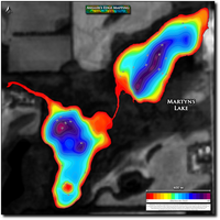
Old Provincial Bathy Charts
These maps were produced by the government a long time ago, using primitive methods. They are not intended for navigation and should not be expected to be accurate.
View full details on your catch log.