Central Fishing Zone
About Central Fishing Zone
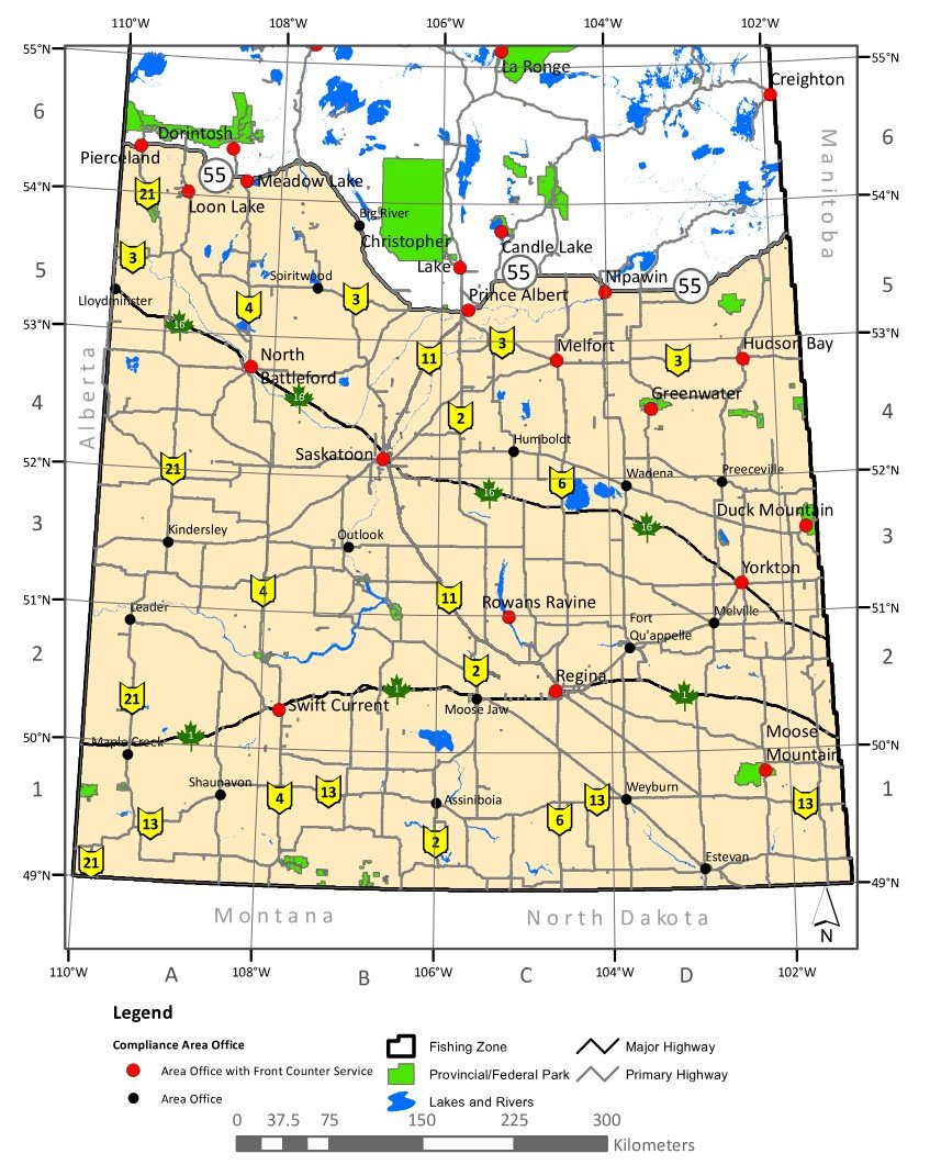
With over 38 million acres and 1997 lakes, the Central Fishing Zone in Saskatchewan offers endless adventures. This zone includes some massive lakes, many parks, and some incredibly popular lakes, including Lac La Ronge, Candle Lake, and Waskesiu Lake. There are some very remote locations within the central zone that require flying in or paddling to get to. Luckily there are also many lakes that are easily accesible by road.
Fishing in the Central Fishing Zone
The fishing season within the Central Fishing Zone is open from May 15, 2024 to March 31, 2025.
The following game fish can be found in the zone: Arctic Grayling, Lake Trout, Northern Pike, Yellow Perch, Walleye, Lake Whitefish, Burbot, Stocked Trout and Sauger.
Candle Lake is one of the most popular recreational destinations in the province. The lake draws huge crowds in the summer to the water and community. In the winter it's a popular destination for sno
Fishing Zone: | Central Zone |
Photos: | 24 photos of Candle Lake |
RM: | Paddockwood No. 520 |
Communities: | Resort Village of Candle Lake |
Parks: | Candle Lake Provincial Park, Waskateena Beach Recreation Site |
Location: | 53.822669397618, -105.29727226295 |
Shore Length: | 73km |
Surface Area: | 32616 acres |
Max Depth: | 16.8 m (55 ft) |
Inflows: | Fisher Creek, Clearsand Creek, Hanin Creek |
Outflows: | Torch River |
Christopher Lake is a popular recreation lake located 40km NNW of Prince Albert. The lake has parks, campgrounds, camps, marinas, beaches, boat launches, and hiking trails to explore. The Resort Villa
Fishing Zone: | Central Zone |
Photos: | 27 photos of Christopher Lake |
RM: | The District of Lakeland No. 521 |
Communities: | Resort Village of Christopher Lake, Bell's Beach, Clearsand Beach |
Parks: | Great Blue Heron Provincial Park, Christopher Lake Nature Area |
Location: | 53.566265824554, -105.82591024771 |
Shore Length: | 18km |
Surface Area: | 1643 acres |
Max Length: | 14.61 km (9.08 mi) |
Max Depth: | 10.1 m (33 ft) |
Inflows: | Christopher Lake diversion |
Outflows: | Christopher Creek |
Emma Lake is a top-rated recreational lake located 12km NW of the Resort Village of Christopher Lake and 46km NNW of Prince Albert. This is one of the most popular recreational lakes in the province,
Fishing Zone: | Central Zone |
Photos: | 35 photos of Emma Lake |
RM: | The District of Lakeland No. 521 |
Communities: | Sunnyside Beach, Guise Beach, Neis Beach, Emma Lake (Unincorporated), Okema Beach |
Parks: | Fairy Island Wildlife Refuge, Emma Lake (Murray Point) Recreation Site, Great Blue Heron Provincial Park |
Location: | 53.60438082944, -105.92050530467 |
Shore Length: | 67km |
Surface Area: | 4364 acres |
Max Depth: | 10.1 m (33 ft) |
Inflows: | Montreal Creek, Emma Lake Diversion |
Outflows: | Christopher Lake diversion |
Greig Lake is a large recreational lake in Meadow Lake Provincial Park. The lake is about 40km from Meadow Lake (City). The Resort Village of Greig Lake and the Provincial Park campground are on the e
Fishing Zone: | Central Zone |
Photos: | 44 photos of Greig Lake |
Communities: | Resort Village of Greig Lake |
Parks: | Meadow Lake Provincial Park |
Location: | 54.454148488114, -108.72320937811 |
Shore Length: | 22km |
Surface Area: | 3998 acres |
Max Depth: | 27.01 m (88.6 ft) |
Kimball Lake is a very popular recreational lake in Meadow Lake Provincial Park 9km west of Greig Lake. There is a subdivision of cabins on the lake, a nice sandy beach, boat launch, store, and a camp
Fishing Zone: | Central Zone |
Photos: | 27 photos of Kimball Lake |
RM: | Meadow Lake No. 588 |
Parks: | Meadow Lake Provincial Park |
Location: | 54.407058694797, -108.82674472975 |
Shore Length: | 7.69km |
Surface Area: | 715 acres |
Max Depth: | 11 m (36 ft) |
Lac Île-à-la-Crosse is a massive (108668 acre) lake. Fort Black is adjacent to Lac Île-à-la-Crosse.
Fishing Zone: | Central Zone |
Communities: | Île-à-la-Crosse, Patuanak |
Parks: | Lac Île-à-la-Crosse (South Bay) Recreation Site, Fort Black |
Location: | 55.590279231434, -107.87233718002 |
Shore Length: | 450km |
Surface Area: | 108668 acres |
Inflows: | Churchill Lake by Aubichon Arm or Deep River, Beaver River |
Outflows: | Churchill River |
Lost Echo Lake is a beautiful recreational lake on the far West side of Narrow Hills Provincial Park just past Piprell Lake. It's surrounded by trees and is nestled in a glacier-formed valley in the C
Fishing Zone: | Central Zone |
Photos: | 32 photos of Lost Echo Lake |
Parks: | Narrow Hills Provincial Park |
Location: | 54.128835150424, -104.74962866594 |
Shore Length: | 5.44km |
Surface Area: | 236 acres |
Max Depth: | 13.72 m (45.0 ft) |
Inflows: | Caribou Creek |
Outflows: | Caribou Creek |
Waskesiu Lake is a huge, incredibly popular lake and the top tourist destination within the Prince Albert National Park. The park offices and resort village of Waskesiu are located on the east shore
Photos: | 75 photos of Waskesiu Lake |
Parks: | Prince Albert National Park |
Location: | 53.961113337169, -106.23097132989 |
Shore Length: | 79km |
Surface Area: | 17369 acres |
Max Depth: | 19 m (62 ft) |
Inflows: | Kingsmere River |
Outflows: | Waskesiu River |
Amisk Lake is a massive (84276 acre) lake.
Fishing Zone: | Central Zone |
Photos: | 7 photos of Amisk Lake |
Communities: | Denare Beach |
Parks: | Amisk Lake Recreation Site, Meridian Creek Recreation Site |
Location: | 54.584789663652, -102.23411737665 |
Shore Length: | 758km |
Surface Area: | 84276 acres |
Inflows: | Sturgeon-Weir River (West Weir) |
Outflows: | Sturgeon-Weir River (South Weir) |
Anglin Lake is a large (3,334 acre) top-rated recreational lake located 23km NNW of Christopher Lake (Village). The far west part of the lake is within Prince Albert National Park with the rest of th
Fishing Zone: | Central Zone |
Photos: | 50 photos of Anglin Lake |
RM: | The District of Lakeland No. 521 |
Communities: | Anglin Lake (Unincorporated Community) |
Parks: | Prince Albert National Park, Anglin Lake Recreation Site, Great Blue Heron Provincial Park |
Location: | 53.721258778807, -105.95602706604 |
Shore Length: | 67km |
Surface Area: | 3334 acres |
Max Depth: | 24.7 m (81 ft) |
Inflows: | Spruce River, Bitter Creek |
Outflows: | Spruce River |